


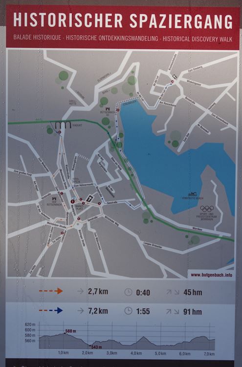
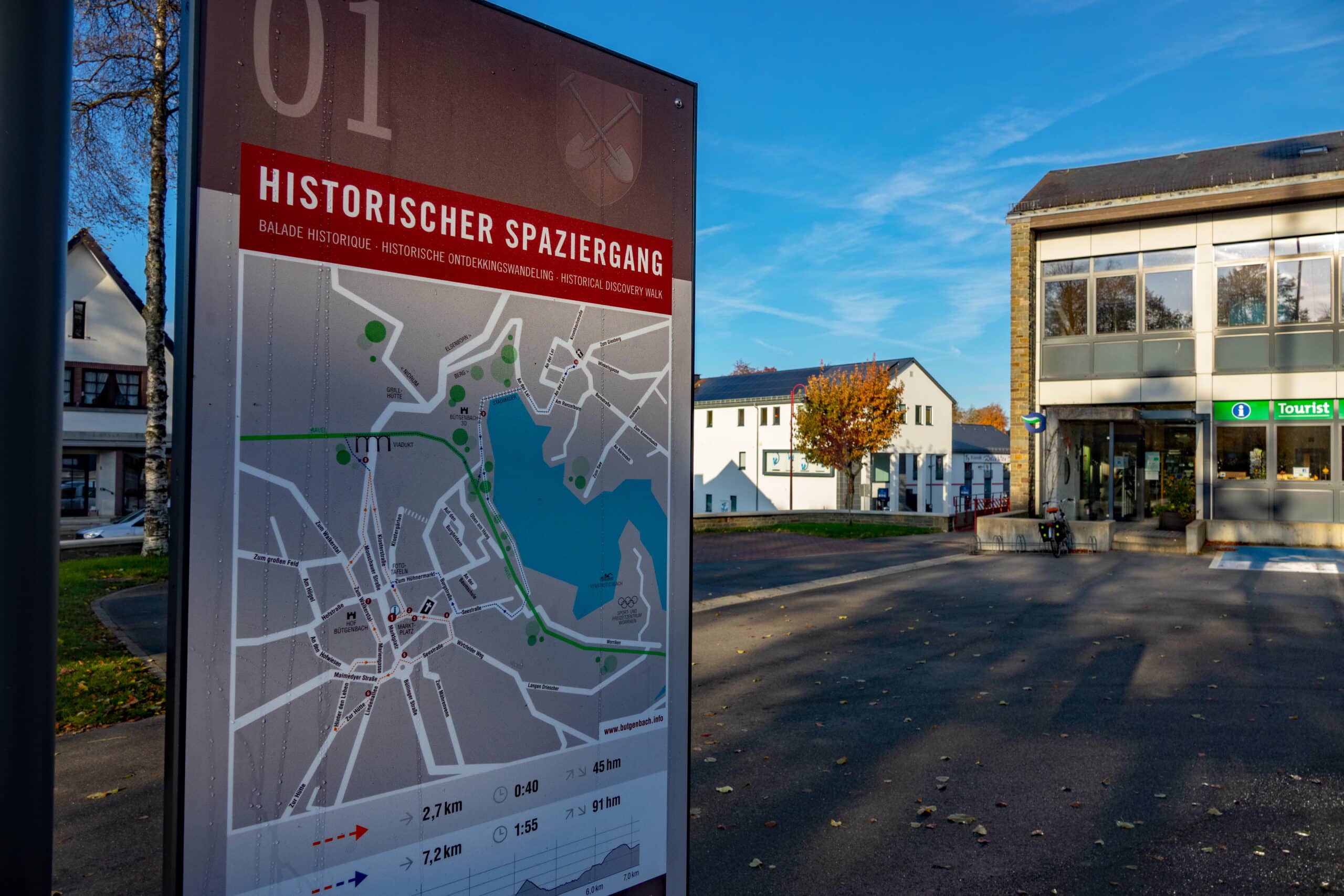
Historical discovery walk Bütgenbach Berg: 2,7/ 7,2 km
Long route: 7,2 km
Short route: 2,7 km
This historical discovery walk through Bütgenbach and Berg takes you on a route across special buildings and facilities. The depictions on the panels bring you back to the past and provide a small insight into the lives and work of the people back then.
The leaflet that goes with it is freely accessible on the Tourist Info entrance and describes the route to the 10 stations using a map. You can choose from two routes; both start and end at the Tourist Info.
2 distances available: 7,2 km and 2,7 km
Tower 1 - Tourist Info Bütgenbach
This historical discovery walk through Bütgenbach and Berg leads us to special buildings and facilities. The depictions on the panels take the viewer back to times gone by and provide a little insight into the lives and work of the people. The accompanying leaflet is freely available at the tourist information office and provides a map with the position of the 10 stations and a brief description.

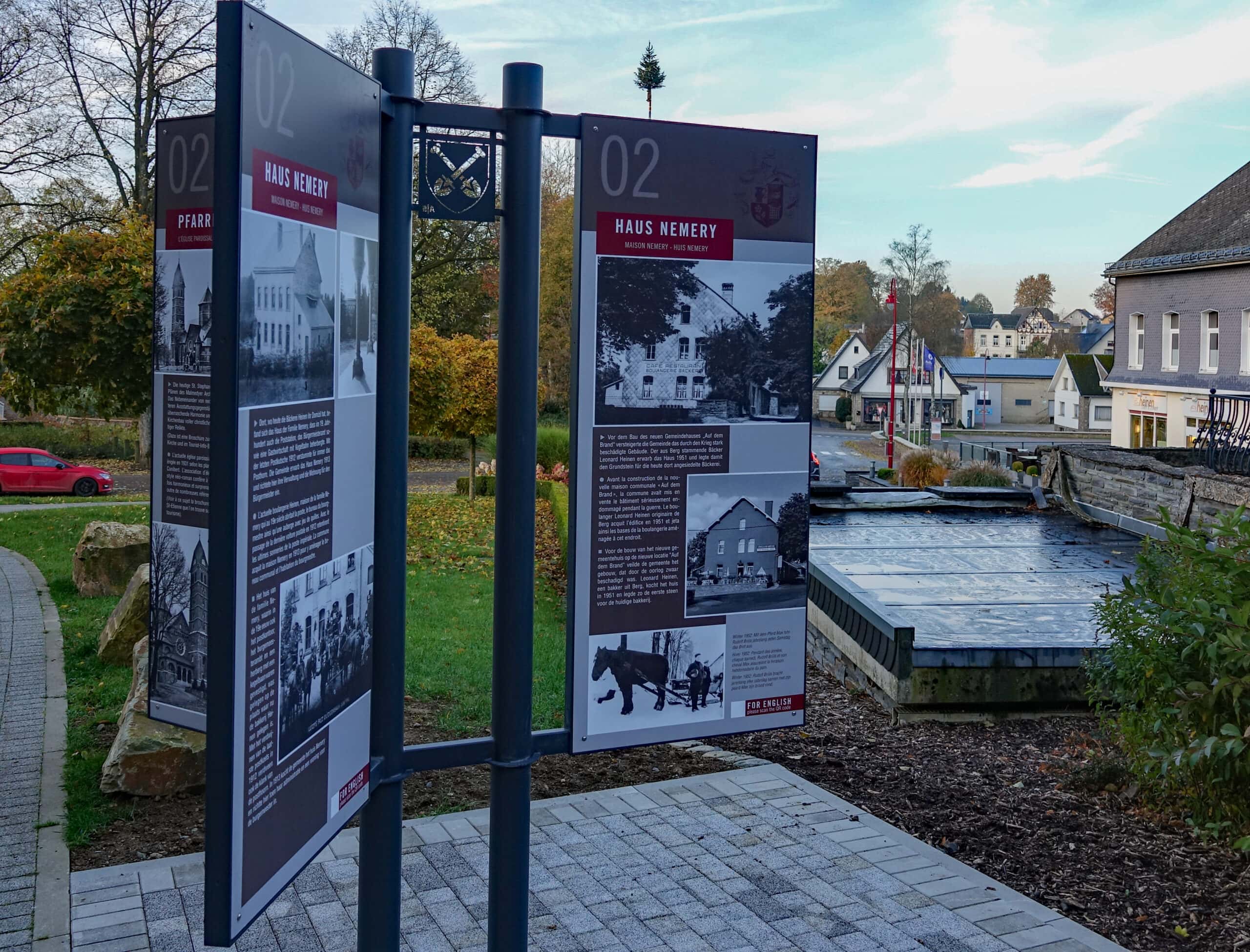
Tower 2 - Saint Stephen's parish church & House Nemery
PARISH CHURCH
Today’s Saint Stephen’s parish church was built in 1931 according to plans by the Malmedy architect Henri Cunibert. The combination of neo-Romanesque architecture and older furnishings lends the building a surprising harmony and extravagance. The church building is also otherwise full of Christian symbolism and historical relics.
(A brochure on St. Stephen’s parish church is available in the church and tourist information office).
In 1131 a church in Bütgenbach was first mentioned in a document. It was located at today’s cemetery and was demolished in three phases between 1938 and 1953. In 1803 it was a parish church for Berg, Elsenborn, Nidrum, Weywertz, Faymonville and Sourbrodt.
In the period from 1932 to 1938 two church towers were to be seen in Bütgenbach.
As the owner of the church, the municipality of Bütgenbach redesigned the entire forecourt in 2017. In the course of this measure, the war memorial, until then standing in front of the church, was redesigned and moved to a place in front of the chapel of the dead.
HOUSE NEMERY
The house of the Nemery family, which in the 19th century also housed the post office, the mayor’s office and an inn with a bowling alley, was located where the Heinen bakery now is situated. With the last stagecoach the Posthorn fell silent forever. The municipality acquired the house Nemery in 1913 and set up its administration and a dwelling for the mayor here.
Before the construction of the new town hall at the new location “Auf dem Brand” the municipality sold the building, which had been severely damaged by the war, by auction. Leonard Heinen, a baker from Berg, bought the house in 1951 and thus laid the foundation stone for the bakery now located there.
Winter 1952: every Saturday Rudolf Brüls brought around his bread with his horse Max. He did this for years.
The boys’ school, built in 1910, was divided into three classes. In addition to the classrooms, the building also housed the teacher’s dwelling. Due to lack of space, the local council had the school replaced by a new building in 1968, which was enlarged nine years later. Since the school merger in 2002, the tourist information office and the police have been housed here.
In 1986, the municipality of Bütgenbach adopted the coat of arms of the von Rolshausen family as its municipal coat. It shows two crossed silver spades in a red field.
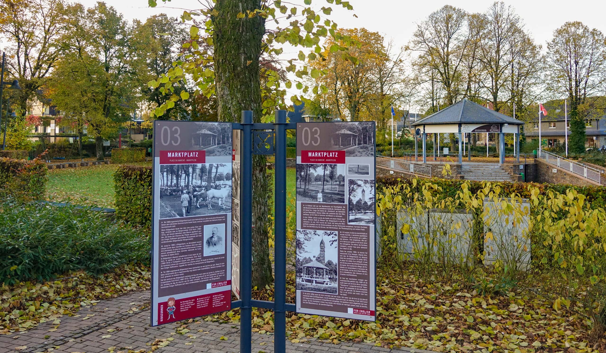
Tower 3 - Market place - School for girls - Pauels & Huby
In earlier times the market area was a wetland. The old name “Vennborre” for the spring indicates this. For a long time, the “Vennborre” was used as a drinking place for cattle and as a washing place. The farmers also filled their water barrels here to supply their cattle with water in summer.
Until 1868, Bütgenbach organised two livestock fairs a year and a fair. In addition to the annual summer market, there are now two smaller markets for groceries and vegetables every month.
In the 1950s the spring was roofed over with a kiosk. Since then its water (the Bütgenbach) has flowed into the sewage system. In July 1973, the minigolf course, which is much frequented today, was laid out and the children’s playground was extended with quiet zones. On the market square the population celebrates festivities such as the kermis, the St. Martin’s bonfire, the horse blessing.
If Bütgenbach has a green oasis here today, it owes it to Mayor Emil Kirch (1882-1913), at whose instigation many trees were planted here, which today make up the charm of the square. A bronze bust created by Gregor Hoffmann honours the meritorious mayor of Bütgenbach.
The brick school for girls was built by the community in 1887. The extension of the school with the amusement arcade followed in 1933. With the extension of the boys’ school all school children found a place there. Afterwards the girls’ school was available to the clubs, later to the police and the Red Cross.
In 1932 Franz Huby, the head of the post office, built his own home, with the option of opening a post office counter and a shop here.
Maria Knauf, the wife of Aloys Pauels senior, produced a special soft cheese in the Pauels house in Mariengasse as a cheese specialist. She discontinued production in 1952.
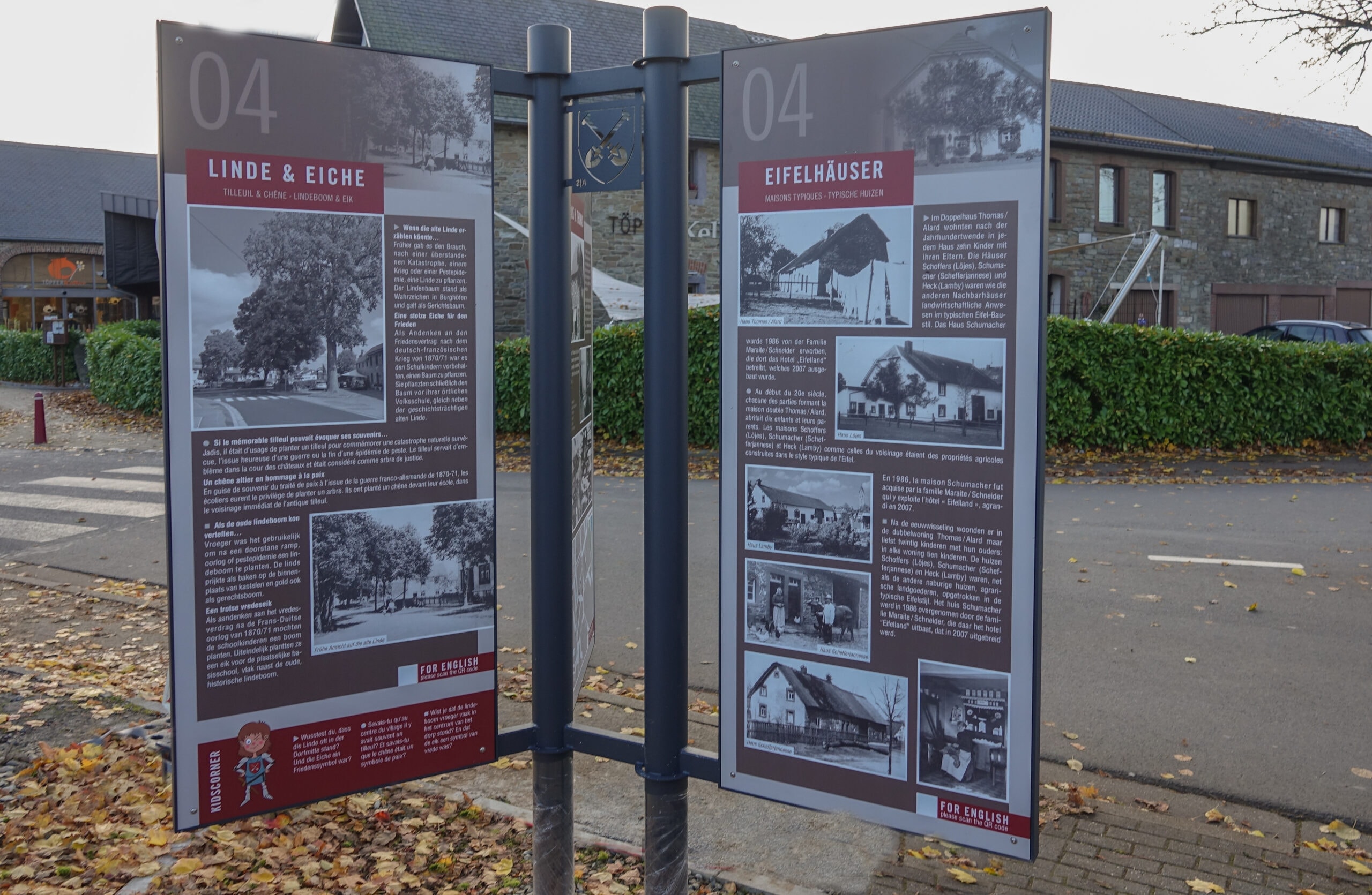
Tower 4 - Hotel Thomas - House Wewesch - Lime tree & Oak - Typical Eifel houses
House Wewesch
Among the three most important buildings in Bütgenbach that have gone down in history is undoubtedly the old Weynand House from the 16th century.
The house name “A Wewesch” refers to a resident of the early 18th century.
The lords of Rolshausen ordered the house (1) to be built for the castle administrator using stones from the destroyed castle. On 12 June 1786, the property manager sold all estates of the Rolshausen family.
Around 1900 the house came into the possession of Jacob Weynand. His son Wilhelm set up a haulage company and an agricultural business in the 1930s. After the death of the spouses Wilhelm Weynand-Wey, the pottery and later the pottery cellar were born.
The middle house (2) has its own history. Construction could have begun shortly after 1815, as could indicate the red sandstone door and windows that might be remains of the destroyed castle wall. Wilhelm Weynand acquired the house after the war and rented it out for various purposes. Later a daughter took over the house.
In the right part of the building (3) the municipality established the first Bütgenbach elementary school in 1834. After the school moved to the market place in 1910, the fire brigade moved to the ground floor, where the fire house was also located. The upper floor was initially used for residential purposes and later by the village associations and the nursery school.
If the old lime tree could tell…
The house with the old lime tree is already marked on an 18th century map. In the past it was customary to plant a lime tree after a disaster, a war or a plague epidemic.
The lime tree stood as a landmark in castle courtyards and often formed the village centre. The square in front of the old lime tree was the fairground for many years.
A proud oak for peace
As a souvenir of the peace treaty after the Franco-Prussian War of 1870/71, it was reserved for schoolchildren to plant a tree. The schoolchildren from Bütgenbach, Berg and Nidrum created the small celebration with patriotic poems and songs, they finally planted an oak tree in front of the local elementary school right next to the historic old lime tree.
House Thomas
Hubert Thomas had his house built in 1930 and opened a grocery store there. As a master tailor, he also set up his workshop there.
Typical Eifel houses
After the turn of the century, ten children lived with their parents in each house of the Thomas/Alard duplex.
The houses Schoffers (Löjes) and Schumacher (Schefferjannese) were, like the other neighbouring houses, agricultural estates in the typical Eifel style.
The house Schumacher was acquired in 1986 by the family Maraite/Schneider, which operates there the hotel Eifelland which was extended in 2007.
Hotel Thomas/Klubert
Before Jakob Thomas bought the left half of the house, Hubert Marquet ran a butcher’s shop there. After the purchase, his wife Anna Cremer opened a small shop. Jakob Thomas then built the hotel with the restaurant in 1939. Daughter Maria and husband Hugo later took over the business, which is still run by a grandson as the restaurant “Zum Pub”.
Tower 5 - Roundebout - Kelternich - Intersection
Roundabout
Today’s roundabout or the former intersection has always been a traffic junction.
The outgoing directions led to Sankt Vith, Prüm, Eupen or Malmedy.
In the turmoil of the two world wars military troops of different countries crossed the junction in all directions.
On the initiative of the province a very obstructive “island” was created at this crossing in 1960, which was soon removed again. The current roundabout has existed since 2004.
Hilgers
Village life at the intersection was dominated by the Hilgers family. Both houses were built in the same style.
August Hilgers, born in 1843, ran the hotel as well as a colonial food store, a clothing store and a flour business. He was also a farmer and in charge of the postal office.
His son, Emile Hilgers, born in 1886, was a doctor; in 1915, he was still visiting his patients in a carriage. His son Hans August Hilgers had started a taxi company. Later, he rented part of his home to a pharmacist, a banker and an optician.
Kelternich
In the laterally opposite house Joseph Hilgers provided in a restaurant food and drink for his visitors, including the passengers of the post coach. His successor, a businessman from Cologne, Joseph Kelternich (husband of Maria Hilgers), opened an ironmongery store in the same building.
In the house Faack (today demolished) were at times a post office, a small inn and a restaurant with accommodation facilities for users of the coach. The entrepreneur Greten acquired the corner building and sold other parts of the house to the carpenter and funeral service company Rademacher.
Consum
Before 1940 a certain Mr. Xhayet supplied the population with food and ran a petrol station in his “Consum” near the intersection. After 1945 his son-in-law Jos. Gilmann ran the business and rented a room as a postal branch to the post office.
Günther Schaus, a businessman from St. Vith, built the Nopri directly at the intersection in 1985.
This initiative gave the village centre a structurally adapted embellishment and upgrading. In 2012 a new investor took over this property and several small shops were opened at the same location.
Intersection
Since several generations the inhabitants living next to the intersection have ensured a successful commercial activity. The guests who were once transported by stagecoach and now by bus and car, as well as the villagers, always had the opportunity to do their shopping at the intersection.
Two families Lauter/Heinen and Niessen (Brüls/Franzen) had their restaurants near the intersection.
Edouard Schleck was a farmer and cattle trader and his wife Katharina ran a shop with a considerable assortment in her house.
Tower 6 - Lindenallee - Lime Tree Alley
The rapid modernisation of agriculture in the 20th century has contributed significantly to the development of our region. Especially the manual work has been replaced by more and more modern machines.
The use of the tractor resulted in a major reversal in mobility developments. Draught animals such as horses, oxen and dogs lost their status as farm animals. Some families earned their living as craftsmen.
In the course of time the inhabitants improved their houses and stables, e.g. by replacing thatched roofs with slate roofs.
After the Second World War the local association life revived; in 1960 the whole village congratulated Mrs. Limburg on her 100th birthday.
House Antonne; owner Wilfried and Margit Schumacher Heck
The spacious house was built with access from the outside to the cellar in 1815.
The favourable location on the Aachen-Trier connecting road made it possible to run a restaurant and a hostel. Carters, who transported bark from the Moselle area to Malmedy on the so-called Leather Route, stopped here.
Two different groups of bricklayers left visible traces on the house: Prussian craftsmen were at the front and a French group of bricklayers worked on the gable and at the back. The present owners renovated the house properly and kept the original elements in the best possible condition.
Museum Heck Lindenallee
About 40 years ago Karl Heinz Heck began to classify the war objects he had found. In the course of the years the collection became ever more extensive, so that 1985 the attic was converted into a museum. Until today he collects remains from the Second World War.
Visitors from all over the world, including relatives of veterans, were already standing in front of his door. With them he visited the sites of the war.
Many tourists, who spend some holidays in Bütgenbach, visit his museum. His address is well known among collectors and relevant experts.
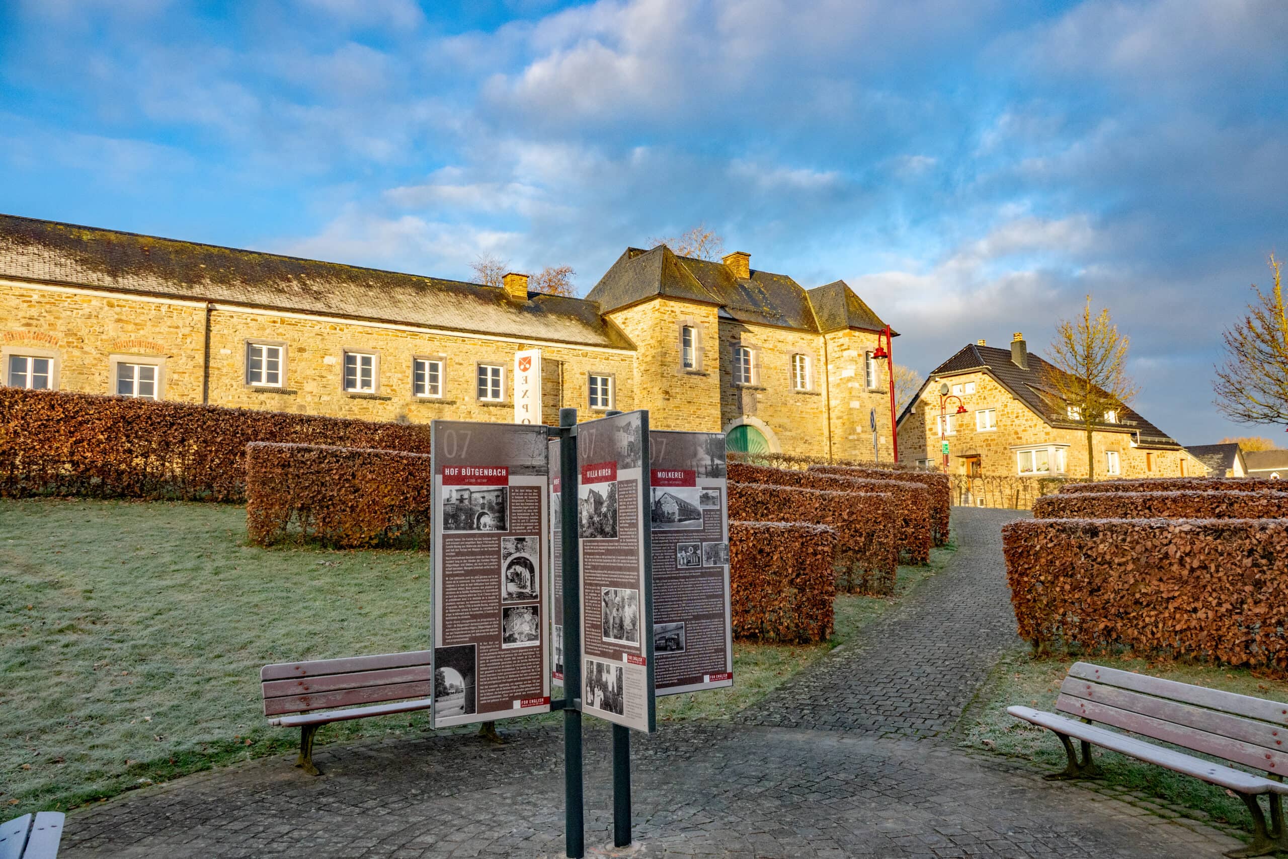
Tower 7 - Hof Bütgenbach
Villa Kirch
The house was built in 1869 by Gerhard Kirch, mayor from 1862-1881. His son Emil Kirch, also mayor from 1892-1913, had the house enlarged. Thus, the same building could accommodate his own apartment as well as the mayor’s office and the post office. After his death in 1913, the mayor’s office was moved to Haus Nemery next to the church (today’s Heinen bakery).
The Villa Kirch was visited by high-ranking officials during the Battle of the Bulge in 1944. The commander-in-chief of the allied forces in north-western Europe, General Dwight D. Eisenhower, visited the headquarters of the 99th US Inf. Division, which was housed there.
At times, the Haus Kirch housed a branch of the Municipal Credit, which was run by the daughter of Mayor Emil Kirch, Elfriede Kirch, until her retirement.
Now the villa is owned by Aloys Heinen. The car electrician ran his workshop there until his retirement.
Presbytery
After the congregation sold the vicarage located at the cemetery, the acting pastor had to move into the presbytery which was built in 1794 and is located in the Walkerstal street, away from the church.
Because the priest always had to walk all the way to the church, he was quite dissatisfied with the new and more remote presbytery. In 1962 the parish bought an accomodation for the priest near the church and sold the remote pastorate to private ownership in 1963.
Dairy
In 1932 a cooperative dairy was founded in Bütgenbach, just like in many other villages. In the beginning only 32 farmers delivered their milk there, but the number of members grew rapidly. The milk was collected in the surrounding villages by horse and cart.
The Second World War forced the dairy to close its business. From 1947 onwards, the difficult period of reconstruction followed. In the following years several enlargements and modernisations were necessary, as the butter and milk business flourished. The purchase of two milk collection tankers in 1972 is proof of this.
Due to the favourable economic development, the number of mainstream farmers fell from 1970 onwards, as more and more people sought employment on the labour market. The decline in the number of farmers was followed by the decline in the number of dairy farmers. In 1980 the Bütgenbach company was taken over by the Büllinger Molkerei.
The municipality bought the buildings and accommodated its construction yard and the municipal police there. After the construction yard moved to Weywertz, the municipality sold the building in 2007 and Philippe Heck set up a banking and insurance business there and Achim Brüls the painting business and DIY store Fatabo.
The Hof Bütgenbach
Its buildings are the oldest in the municipality. Unfortunately, there is no precise information about the date of their construction. Tradition mentions several generations of the Reiffenberg family as bailiffs or sheriffs and thus presided over the fate of the village between the 15th and 17th centuries. The buildings were renovated and enlarged several times. After 1750, the Baring family, originally from Wallerode, bought the entire complex and had the building with the coat of arms erected at the northern entrance to the estate.
In 1810 Q. Dethier and G. Alard acquired the building and the land. Due to death and mismanagement a sale was pending in 1863. J.N. Hilgers became the new owner. Now the “Hof” remained by marriage for 100 years in the hands of the families Hilgers, Oligschläger and Steiner, who used the building and the land for their agriculture. Due to a lack of investment the building was in ruins.
In order to save the property, the municipality of Bütgenbach bought the area. It then merged with the neighbouring communities to form an intermunicipal association, which together built the retirement home here. The property was moved into in 1993. The front part of this four-winged building remained the sole property of the municipality of Bütgenbach. Cultural events of various kinds are intended to bring more vitality to this enclosed area.
Niessen (Brungs)
The Brungs house, built in 1713, belonged together with the post stable to the court of Bütgenbach.
Johann Niessen and Maria Limburg all lived together with their 15 children (nine sons and six daughters) in the rather small house. Situated in the Walkerstal street, completely covered with straw, the house has been largely demolished in the meantime, leaving some remains of the house.
Café/Restaurant Brüls
The local building on the Monschauer Straße was already used as a restaurant and for agriculture in the 19th century. Great-grandfather Paul Brüls bought the complex from Peter Weynand in 1889. Now the fourth generation of the family runs the business, which has developed into a modern restaurant with a skittle alley, hall and grill.
The Court with the post stable (picture no.10)
To the right of the gate building of the manor is the post stable.
– The post stable served as accommodation for the horses and the stagecoaches. The stagecoach service began in Bütgenbach in 1828 and ended in 1912.
Tower 8 - Viaduct
The mill
The mill of Bütgenbach was located in the Warche valley near the railway bridge. The date 1825 was engraved above its door. The watercourse of the Warche River provided the driving power for the mill, with a water wheel activating the entire mechanism via drive belts.
Because the mill had to be demolished during the construction of the dam, the Schommer family built a new mill in 1934 in the Elsenborner Straße. This mill was powered by electricity. Here, the farmers let grind barley, grain or oats. They brought the grain to the mill by horse-drawn carriage or sleigh. While barley and grain were ground, the oats had to be crushed. Until around the 1960s, the mill operated in the shadow of the viaduct.
The laundry
Not far from the old mill was the building of the Elsenborn camp laundry, which was built here at the end of the 19th century. Besides the military, other customers also had their laundry cleaned here. The Schommer brothers, who ran the mill, also took care of the laundry and initially provided the transport of the laundry by horse-drawn carts.
A steam boiler outside the building was fed by water from the Warche and heated with coal. Soft soap and soda served as washing detergent. Even at that time, the washing water was clarified after the washing process.
In the hall there were vats for soaking the laundry, three washing machines and a spinner; it were all belt-driven machines. After drying, the laundry was ironed by mangle and then folded. In the laundry were about ten workers and three stokers. In 1924 the company had to close down due to intense competitive pressure.
Viaduct
The Weywertz-Jünkerath railway line, opened by the Prussian Kingdom in 1912, had military reasons. The military training area Elsenborn had to be reached. A total of 12 bridges were built on the territory of the municipality of Bütgenbach. The most important one was the Bütgenbach Viaduct, which, with its six arches, a height of 30 m and a length of 104 m, connects the side valleys Kolberg and Burgfelder.
Already in the World War I (1916) the bridge was almost blown up by a Russian spy. Another unsuccessful attempt to blow up the bridge – this time by Belgian military – was made in 1940, but was thwarted by a German special unit.
When the Wehrmacht withdrew from Belgium, many bridges and the viaduct were destroyed. On 13 September 1944 a German command blew up two pillars. At first, the Belgian Railways only wanted to build an emergency bridge, but decided to renovate the pillars anyway. Already in March 1946 trains rolled over the restored bridge again. In May 1952 the railway line Weywertz – Jünkerath was closed for passenger traffic.
Freight traffic, especially timber and coal, was maintained until the early 1980s. From 1982 the Losheimergraben – Malmedy railway line was closed; timber transports from Germany and Antwerp to Büllingen were handled via Sourbrodt and Raeren. In October 2004, the last train, a special tourist train passed the viaduct. In 2007 the tracks were removed and in 2014 the Ravel line was built instead.
Kollberg and Burgfelder
Both hilly landscapes are connected by the viaduct. Kollberg, also written as Kohlberg, suggests that charcoal burners used to work there in the past. Nowadays only the common name Kollberg is remembered.
Every year between March and April, the Koll flowers, better known as daffodils, bloom on the wetland between the Warche and the viaduct – a beautiful natural experience.
The castle fields near the former castle are now used for agriculture or serve as construction area.
Restaurant Bei Chresten
The inn was the last house before the viaduct on today’s Monschauer Straße, along the once busy road to Elsenborn. The manager was a passionate skittle player and built a skittle-alley. He thus created an additional source of revenue.
Tower 9 - Castle - Dam
Worriken
In the 1960s, the touristic use of the reservoir and its banks began.
In 1968 the French-speaking community decided to establish a sailing school with affiliated half-day classes. Until the early 1980s, the WORRIKEN sports and leisure centre, now owned by the German-speaking community, was built in several phases. Bütgenbach thus became one of the most important strongholds of tourism in East Belgium.
The dam
In 1929, under the direction of the Italian company OMODEO, the construction of the dam began at the instigation of the electricity company SERMA. Many locals found here a possibility to earn a good extra income.
The future main access road from Bütgenbach to Berg was diverted and also the road leading directly from the railway station across the lake to Berg was replaced by a new road which went over the dam wall.
In 1932 the dam was completed and only one year later electricity generation began. The power control centre and the engine room with the turbine are installed in two vaults of the dam.
In 1995 ELECTRABEL commissioned extensive repair and beautification work on the dam. Since then the crossing has also been closed to all motor vehicles. Further repair work at the foot of the dam led to the complete emptying of the lake in 2004.
The castle
We find the village of Bütgenbach at the beginning of the 13th century in the possession of the Counts of Limburg. Waleran the Younger, a bellicose contemporary, was involved in numerous quarrels with the bishops of Cologne and Liège. In 1237, Liège mercenaries destroyed a “tower” in Bütgenbach – probably a residential tower, the forerunner of the castle.
In 1266, the Monschau-Bütgenbach dynasty died out and the castle, which had been enlarged in the meantime, was handed over to the house of Valkenburg.
Later, the property passed to the Counts of Sponheim-Vianden and at the beginning of the 15th century, finally to the House of Nassau-Orange.
Over the centuries, the castle was destroyed several times and restored by the subjects, often against their will. In 1689, French troops caused considerable damage, after which only a few parts of the building were rebuilt for residential purposes.
The planned sale towards the end of the 18th century was preceded by the demolition of the buildings in French times.
An 18th century drawing by the Malmedian artist Mathieu Xhrouët shows the castle in the east as a residential dwelling. While the north-eastern part of the manor was in ruins, the western part, a two-storey manor house with a hipped roof on both sides, was in good condition. Three round towers, one without a bonnet and two with curved bonnets, were attached to the dwelling house and their foundation walls probably date from the time of the fortress.
Tower 10 - Berg
- BERG
The village of Berg was first mentioned around 1530. At that time, however, the small village belonging to the Hof Bütgenbach was called “Uffemberg”, which means “on the mountain”. In French, they even spoke of “Berg-sur-Warche”. The origin of the name therefore clearly goes back to the altitude of the village. - CHAPEL
The chapel in the centre of the village is 585 m above sea level and the highest point of the village in the direction of Elsenborn is even 620 m high.The foundation stone for the chapel was laid on the Sunday of the fair, 11 October 1959. The chapel was dedicated by dean Hilgers on 3 June 1962. - SAINT ODILIA
The Odilia spring is located at the entrance of the village. The constantly running spring water and the inscription on the basin “Gib, dass ich sehe” (Give that I may see) remind us of the patron saint of Berg. Even in earlier times, the “water of the eyes” was used by the travelling people for refreshment.. - QUARRY
On the way towards Wirtzfeld there is a quarry that was once run by Peter Heinen. Many a house was built with these stones. Today there is a nice resting area here. - WORKWith a huge wagon train, the villagers went to the “Bergervenn”, where they were busy for an entire week cutting peat. Other important occupations were agriculture and forestry. The spruce used to be considered the “bread tree of the Eifel”.
- SCHOOL
The old school building has changed a lot since it was built in 1840. Most recently, it was home to Ida Wey-Heinen’s grocery shop. From 1910 to 1984, the school was located in the village centre, which is now home to the village house.
Tipp
There will be a quiz rally for the children. Whoever finds the solution word will get a little surprise!
Details
Code :
BUT09
Start :
Touristinfo, Marktplatz 13 a, 4750 Bütgenbach
End :
Touristinfo, Marktplatz 13 a, 4750 Bütgenbach
Km :
km
Vertical meters :
m
Off-road :
10%